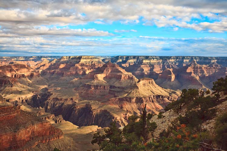
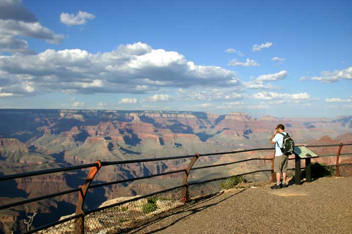
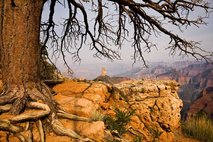
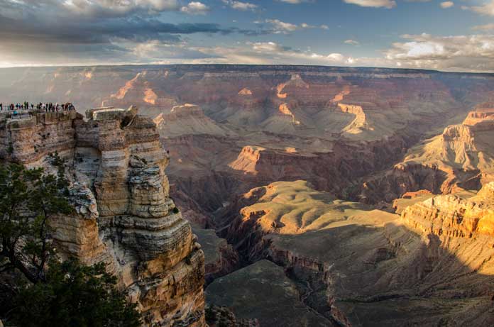
The Grand Canyon is something everyone needs to see at least once. Standing at the rim’s edge will leave you in awe of this massive creation. The sheer size and depth are incredible, along with the views from the rim’s edge. The different colors of the layers of rock present a geological map, leading back millions of years. The Colorado River continues its path through the canyon as it has done so for many years. The canyon is home to thousands of species of plants and hundreds of species of birds and reptiles that call the canyon home. If you’re not content to enjoy the view from the top, hiking down into that canyon or taking a mule ride will open up more fantastic opportunities for things to do in the canyon and hidden sights to see.
Table of Contents
North Rim or South Rim
The Grand Canyon is divided into two rims, the North Rim, and the South Rim. The South Rim is on the Arizona stateside, and it is open all year long. Winters can be cold and snowy, but ideal for making amazing pictures at the canyon. Camping is available as well as lodging. For any backcountry activities such as hikes or camping in the canyon, please obtain the necessary permits which you can get on the site. This rim receives the bulk of all visitors, and summer months can be crowded. Transportation services such as shuttle buses are available to you.
The North Rim is less visited but is still a sight to behold. At over 8,000 feet in elevation, there are no transportation services, so the only way to travel is by road. Located on the Utah stateside, the North Rim takes much longer to get to. Since it is so remote, the North Rim is only available to visitors from May to October, after that weather conditions make it treacherous for travelers. During the winter, the North Rim can still be reached and explored by skiers and snowshoers, but a permit must be obtained to do so.
Grand Canyon Secrets
The view from the top will leave you staring for hours, but inside the canyon, there are more hidden secrets and many more things to see. There is a Grand Canyon graveyard which lies quietly within the park. To find the cemetery, you will need to follow the signs that say “Shrine of Ages.” Also, the canyon has hidden waterfalls, but you have to hike or mule down into the canyon to experience them.
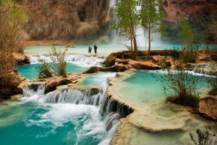
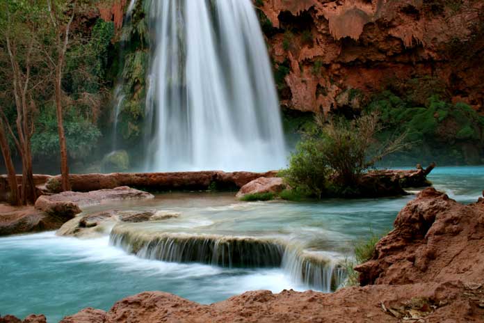
One of the best waterfalls to see is the Havasu Falls. A combination of the components calcium carbonate and magnesium in the water create a bright-blue color. The falls are located near the Havasupai Indian village of Supai, which can only be reached by foot or mule. The hike is strenuous, so be prepared. It does cost to get into the area, and camping is an extra cost, but the 100-foot falls of turquoise blue water are breathtaking. Try the Havasupai Lodge or the Havasupai campground after exploring the waterfall to rest from your hike.
Where to Rest Your Tired Feet
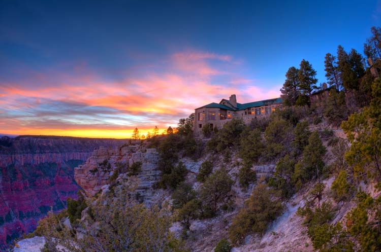
The El Tovar Hotel and the Cliff Dwellers Lodge are two great options to put your feet up after a long day of exploring. El Tovar is the primary facility used for lodging and is located on the North Rim of the Grand Canyon. Dining is available for all meals at El Tovar so you can fuel up before you start your day or have a nice dinner after. The Cliff Dwellers Lodge is located close to the canyon and offers a 24-hour check-in for your convenience. You don’t have to go far for your meals; you can eat at the Cliff Dweller’s Restaurant.
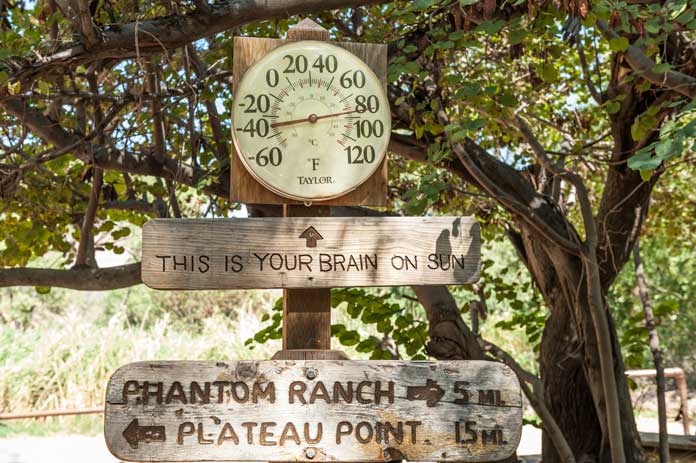
Phantom Ranch can only be reached by hiking, a mule ride, or rafting down the Colorado River. Resting on the bottom of the Grand Canyon, mail received there is delivered only by mule, and the mail will be stamped saying just that. It is a popular stopping point for hikers and overnight mule trips. Please make your reservations well in advance to stay at Phantom Ranch. Accommodations at the ranch are included when you participate in an overnight mule trip to the bottom of the canyon.
Grand Activities
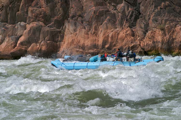
River Raft Trips are exciting and an excellent way to see the canyon. There are quite a few companies that do the raft tours, which can be one day or many days, depending on the experience you would like to have. Multiple days will result in camping or lodging on the floor of the canyon, creating quite the adventure.
You can hike, raft, ride a mule, but what better way to see the canyon than by helicopter ride. There are several helicopter vendors to choose from to experience the ultimate aerial views of the breathtaking canyon from above. Tours can range from 20 minutes up to four hours depending on what you choose.
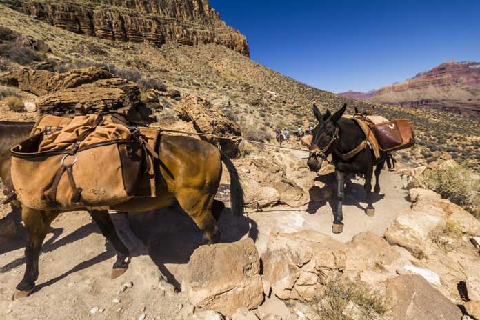
Mule rides are offered as an alternative to hiking down into that canyon. Mules are sure-footed, and these mules are well trained in navigating the canyon safely. Rides can be anywhere from three hours to multiple days. Overnight mule rides into the canyon stay at Phantom Ranch at the bottom for the evening. These rides fill up to a year in advance, and there is also a wait-list. If you are considering riding a mule into the Grand Canyon for this once in a lifetime opportunity, please plan and make your reservation soon.
The Grand Canyon is an unbelievable sight. Pictures do not do the canyon justice; you have to see it for yourself. You can gaze at this amazing creation from one of the rims, or ride a mule to the bottom. Try a helicopter ride to see more of the canyon than most ever will. Don’t forget to try the hike to the Havasu Falls, or raft down the Colorado River. The options available are spectacular, just as the canyon is.
The best trails of Grand Canyon’s North and South Rim
If you’re traveling to Arizona, then you should visit one of its main attractions; the world famous Grand Canyon. Hiking in the Grand Canyon is an excellent way to explore this fascinating area. There are many trails on the North and South Rim to choose from. Here’s a list of some of the most beautiful trails you can consider if you plan to go hiking in the Grand Canyon.
Above the Rim
For the leisurely day trip, there are many hikes and trails above on the rims. They are easy to strenuous, and you can see awe-inspiring views of one of the top attractions in the U.S. below you. Have lunch at a picnic table and don’t forget that camera to capture these memories and views while hiking in the Grand Canyon.
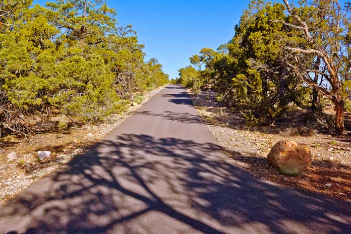
Rim Trail – South Rim
This easy hike is a favorite of visitors who arrive at the Grand Canyon. The trail is mostly paved with slight inclines although it is mostly flat. Shade trees cover some of the trails for a nice break from the sun along this 3-mile hike that starts from the village area and travels to what is called “Hermits Rest.” There is no water available, so you need to make sure to bring plenty of it. This trail gives visitors those been searching for along a beautiful, quiet trail.
Hermit Trail – South Rim
Hermit Trail is a steep trail that offers a couple of different options along the way. The first option is a hike to Santa Maria Spring which is about 5 miles roundtrip. The second option is to hike to Dripping Springs which is about 7 miles round trip. Experienced hikers should only try this trail, as it is steep, rugged, and mostly unmaintained.
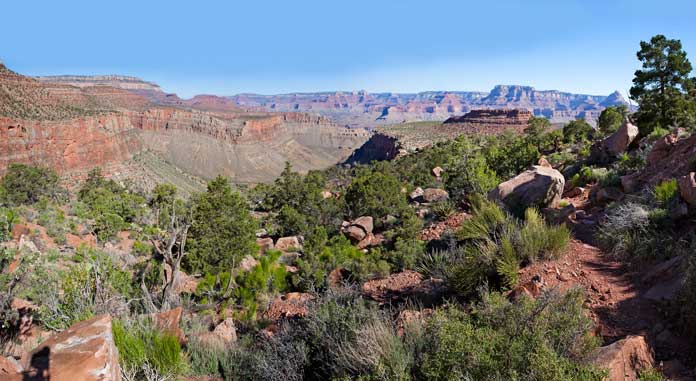
Grandview Trail – South Rim
If you’re looking for a challenge and are an experienced hiker, then the Grandview Trail is for you. This is a very steep trail totaling about 2 miles to Coconino Saddle, or 6 miles round trip to Horseshoe Mesa. Climb this unmaintained trail for some great Grand Canyon scenery.
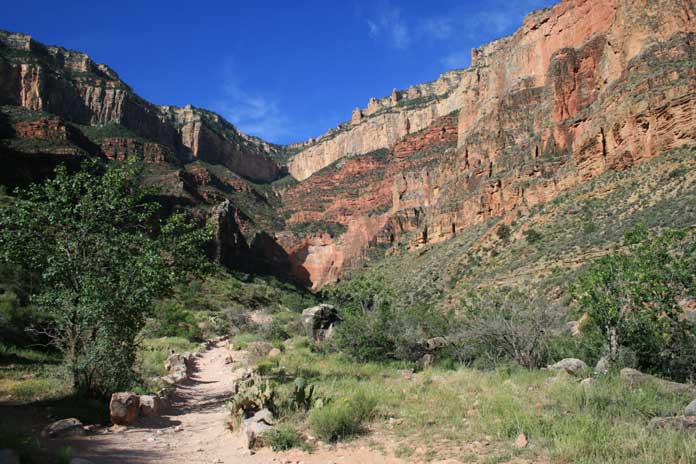
Bright Angel Trail – South and North Rim
Bright Angel Trail touches both edges and also crosses down into the canyon and is one of the most popular trails in the park. From the South Rim, the Bright Angel is steep, and hikers can walk up to 12 miles in a single day on this trail that starts from one rim and crosses the canyon to the other. The North Rim has a section of the trail that is about half a mile on a paved trail with excellent views of the canyon.
Bridle Trail – North Rim
This trail is a relatively easy walk. Dogs are allowed too but have to keep them on a leash. Birders, hikers, and walkers will love this trail that stretches from the Grand Canyon Lodge to the North Kaibab Trailhead. People use this trail moderately, and the Bridle Trail is a little over 3 miles round trip.
Ken Patrick Trail – North Rim
This 10-mile strenuous hike is not for the faint of heart. It is rocky, remote, and watch out for the mules that use the trail as well. It takes about 6 hours to go one way, and winds through forests and along the rim for a remote Grand Canyon feel. The trail descends into a smaller canyon and then back out. This is for experienced hikers who want some beautiful scenery along a less traveled path.
Uncle Jim Trail – North Rim
Uncle Jim Trail got named after a game reserve warden who, to increase the deer population killed 500 mountain lions. It is a 5-mile loop trail that leads to a fantastic viewpoint at the end of the trail which is marked by a mule tethering frame. It takes a few hours to complete the trail, and there are some steep sections to climb. Mules also use this trail, because they ride people down into the canyon.
Cliff Springs Trail – North Rim
This one-mile roundtrip hike travels down a forested ravine to a large boulder rests and where you will find a quaint spring. This trail walks along pieces of the side canyon and is less traveled than many of the other main trails. Much of the Cliff Springs Trail is flat and smooth, and the scenic views along the way are breathtaking.
Roosevelt Point Trail – North Rim
Enjoy a quick, 20-minute hike on the Roosevelt Point Trail that is under half of a mile roundtrip. This is a wooded trail that continues as a loop and great views of the canyon. Sit and enjoy the scene before you on one of the benches placed along the way. Relax and enjoy the scenery and atmosphere of the canyon and Tritle Peak.
Point Imperial Trail – North Rim
The Point Imperial Trail is an about a 2-hour hike and is 4 miles round trip. The trail is considered an easy trail and is suitable for most anyone. The trail passes through an area of the Kaibab forest that is still recovering from a wildfire. Start at the Imperial parking lot where the trail begins through the trees or remnants. The trail does touch the rim where those fantastic views await the hiker. Point Imperial Trail is mostly flat, comfortable, and well maintained and an excellent choice for those who want a nice, light hike or walk.
Best of Both Worlds
For those that are looking for the ultimate experience, the Rim-to-Rim hike is what you’re looking for! Hikers will cover approximately 14 miles and descend 6000 feet to the bottom of the Grand Canyon before hiking back up the 4500 feet and almost 10 miles up to the opposite rim. The best times to try to complete this hike is from about mid-May through mid-June, and then again from mid-September to mid- October. Any other time, and it will be either too hot or too cold and dangerous to attempt it.
Hikers should take the shuttle to the North Rim and stay at the Northam Lodge or Campground and then start out on your adventure the next day using the North Kaibab Trail. Once you reach the bottom, you can stay at Bright Angel Campground or Phantom Ranch for a night or two before continuing. Each leg of the journey is approximately 6 miles long before you reach the next place to stay. It is a strenuous hike both down and backs up to the Bright Angel trail, but hikers take several days to accomplish it, and state that is was the hike of a lifetime.
Grand Trails and Hikes
This list is not complete, and there are several other hikes and trails available. The Grand Canyon is massive, and there are many choices both on the beaten path and off. Experience a natural wonder of the world and see the canyon at sunset or sunrise for the beauty you have to see to believe.
The Best Places for Photos in the Grand Canyon
The United States has thousands of miles of landscapes stretching from the Atlantic to the Pacific Ocean. White sand beaches to the Rocky Mountains, to the rolling plains, the scenery is constantly changing, and people love to explore it, always finding pleasant and beautiful surprises that nature has created. One of those surprises might be the mighty Grand Canyon. The Canyon is nature’s way of showing off, and millions of people visit to see the gorgeous creation and to capture some of the best photos they will ever see or take. Where will you take your photos at the Canyon?
Grandview Point
Grandview Point is the southernmost point on the south rim and has great photo opportunities. This point is one of the highest and receives a lot of rainfall, making the trees and vegetation thicker and taller. The area can be reached using the one-mile side road and upon your arrival, consider hiking down the Grandview Trail for the best picture spots. The canyon stretches for miles from this high point, and you may be able to see the Grapevine creek at the bottom if you hike down the trail a bit. This is one of the top picks for photo places at the Grand Canyon.
Yavapai Point
Yavapai Point is no secret when it comes to one of the best places in the Canyon to get your stunning pictures. Parking is limited, and it is popular with tourists, so be prepared for lots of photographers and visitors. This point offers some of the best panoramic views of the area, and it is one of the closest views of the Colorado River below. Views up and down the gorge where the river lies are unobstructed, providing the perfect opportunities to get photos of both the beautiful canyon and the water below.
Lipan Point
You will need a vehicle to get to Lipan Point, as it branches off the main scenic drive. A spur road will lead you to a parking area where you can start your picture excitement. Your view will look over the Seventy-five Mile Creek and Escalante Butte. The west view stretches as far as the eye can see and is quite impressive. You might be able to see a glimpse of the water rapids to the west, as the creek joins the Colorado River. The 8-mile trail is called the Tanner Trail, and its starting point is also located a short distance from the parking lot if you wish to take a nice hike and capture more photographs.
Mather Point
Mather Point is one of the easiest to reach and because of that is one of the most popular places for photos. Mather is a short walk from the visitor center and has a large area for viewing. There are two railed overlooks as well as many other viewing stops along the rim. Here visitors can see the sheer cliffs as well as views of the canyon. Photos of the canyon edges are one of a kind, and you can show your finds how deep and large it is. The Rim Trail close by offers views all the way to Yavapai Point, so there are many different angles to photograph the canyon from.
Havasu Falls
The Havasu Falls located at the bottom of the canyon is one of the most photographed and talked about places in the entire U.S. if you can get to it. The falls require a 10-mile hike each way, and the trail can be difficult. If you do reach the falls, plan to be amazed. The minerals in the water make it a blue-green color, and against the backdrop of red canyon walls, it creates an impressive and dramatic scene. A series of drop create the falls off along the rock, letting the water continually flow down and finally out at 90 feet overhead into a blue-green pool below. If you can make it to the falls, it will be one of the best places you have ever photographed or seen.
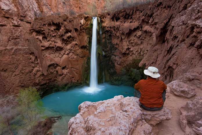
Mooney Falls
If you made it to the amazing Havasu Falls, congratulations! Now that you saw the awesome beauty of the blue-green water, would you care to walk just a little further? About one mile past Havasu falls lies Mooney Falls, another breathtaking place of splendor you don’t want to miss. Travel past the campground to find the fantastic Mooney Falls. Mooney Falls has two falls. The first is a spout of water that falls over 200 feet! The steep drop creates a pool which flows to a much wider and smaller second waterfall. The view will be from the top of the falls, but if you want that spectacular picture, you will have to find a way to the bottom. There is a steep trail with a “proceed at your own risk” sign, so use caution. Mooney Falls has several myths as for how its name came to be. The first is that it was named after James Mooney who perished here as he tried to save his injured friend by attempting to climb back to the top with his friend tied to his back. The second theory is that James was a prospector and was lowered down the cliffs when the rope jammed where he eventually fell to his death.
Bright Angel Point
The Bright Angel Point and Trail are also among the most popular places frequented on the National Park. It is located on the north rim of the canyon. A 0.4-mile trail starts behind the Grand Canyon Lodge and leads visitors to the viewing area. There are jaw-dropping views of the rock cliffs and of Roaring Springs Canyon, which lies to the east. The viewing area has sheer drops on all sides, and there are unobstructed views of the canyon south, east and west. This point is one of the easiest to reach and lies near the hub of excitement around the lodge.
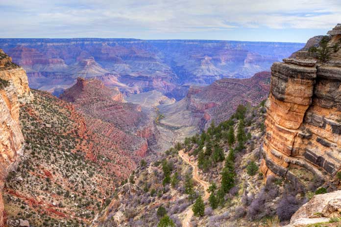
Photo Secrets
It’s no secret that when taking a photo, lighting is the key. Many people flock to the rims during sunrise or sunset for pictures most can’t even put into words. The real secret to getting that perfect picture at the Grand Canyon is actually to go into the canyon, not just on it. The views from the floor looking up do the canyon justice by presenting different angles many people won’t ever get. Capturing pictures of the waterfalls and sheer rock canyon walls from the bottom are astounding and exciting. You will want to frame and show those pictures to everyone. Standing on the rim or hiking down into the canyon will offer everyone the same opportunity; to capture images of one of the nature’s greatest accomplishments and it’s up to you to determine where to capture the moment.


